


 Newsletter
 Online Store
 Login
Login


Race Coverage

RACE Coverage
Namib Race (Namibia) 2026: COURSE DESCRIPTION
The Namib Race 2026 starts on 16 August and takes place in the oldest desert in the world in the beautiful country of Namibia. The race takes place in the Namib Desert within the Namib-Naukluft and Dorob National Parks and finishes on the beach close to Swakopmund, which is our host town for the event.
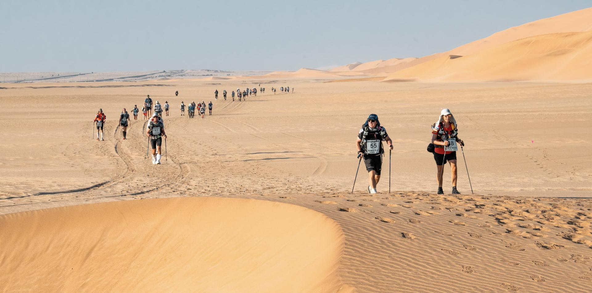
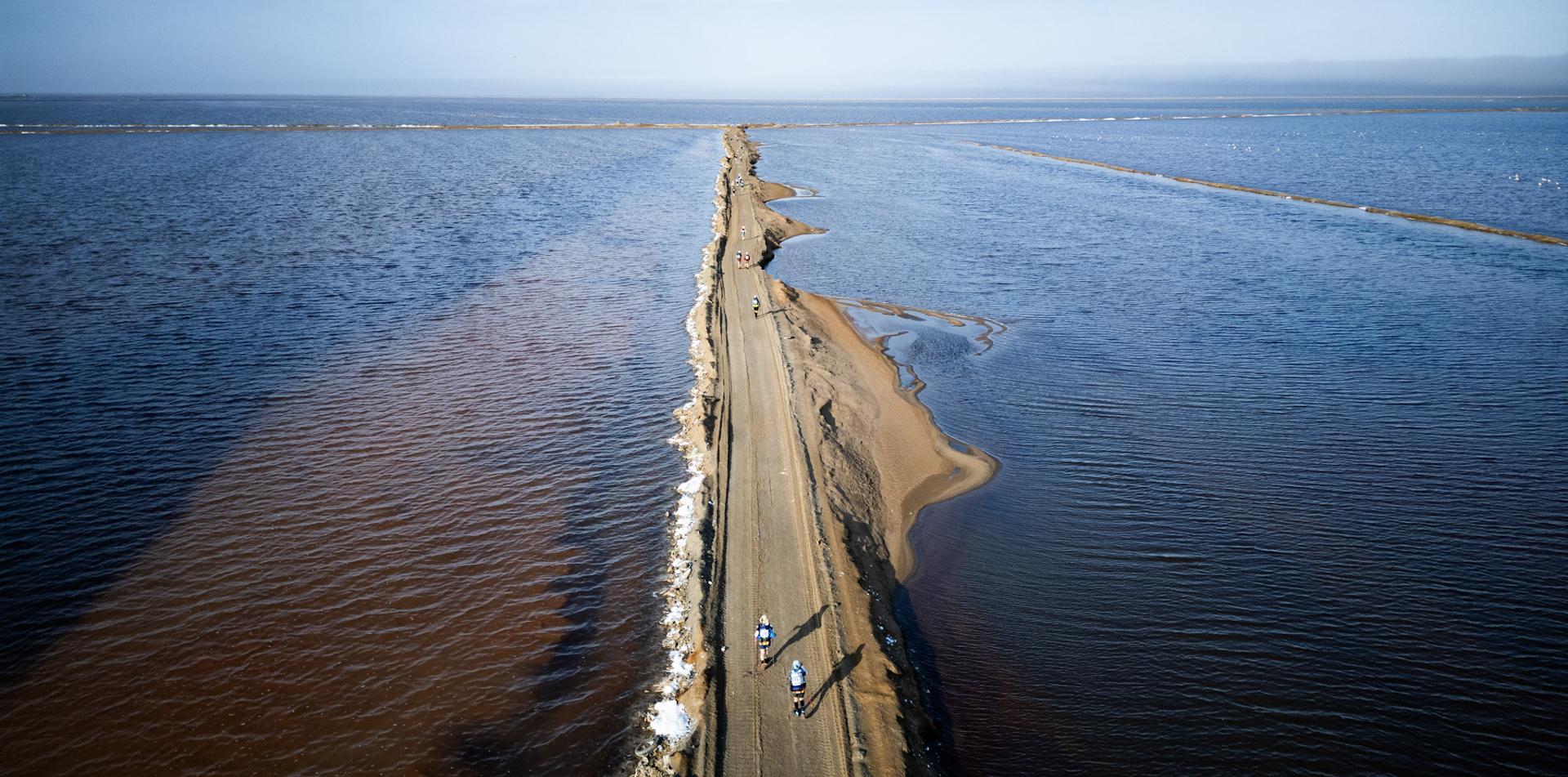
This is a true desert race with the opportunity to see iconic desert landscapes. You will be treated to the full spectrum that a desert has to offer with diverse scenery and terrain. This includes running into the Namibian ‘Moon Valley’, traversing salt pans, staying in the ruins of an old ostrich farm, passing salt lakes which are home to flamingos, running over the infamous dunes of the Namib desert and into dry riverbeds where a hint of water gives way to lush green vegetation.
More detail on the course can be seen below including a map, stage distances, the elevation profile, details about the terrain, checkpoints, cut-off times and The Long March which is Stage 5.
Final course notes will be given to each person in Namibia at the competitor check-in before the race.
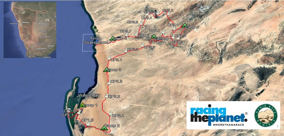
MAP OF THE COURSE
The map here shows the approximate route of the course showing each stage with the six Camps shown and the finish line on the beach just south of Swakopmund.
The host town is Swakopmund. The start of the course is 50 kms / 31 miles south of Swakopmund and it winds its way back through varied desert landscapes and Namib-Naukluft and Dorob National Parks towards Swakopmund. We have special permission to enable us to acces certain areas that are normally closed to visitors.
VIDEO OF THE COURSE

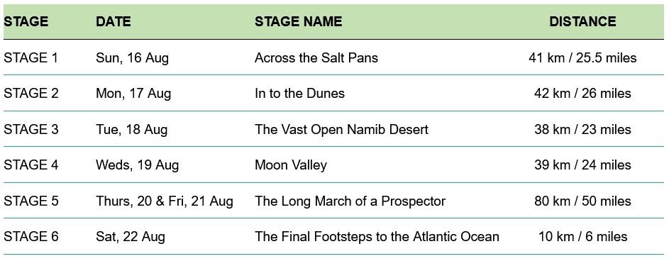
STAGE DISTANCES
The distance for each of the stages of the Namib Race can be seen below. NOTE that the Long March is on Stage 5 and will take place over two days. The actual planned distances for each stage will not be finalized until closer to the race but will be close to the distances stated below.
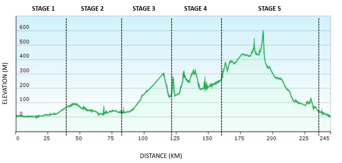
ELEVATION
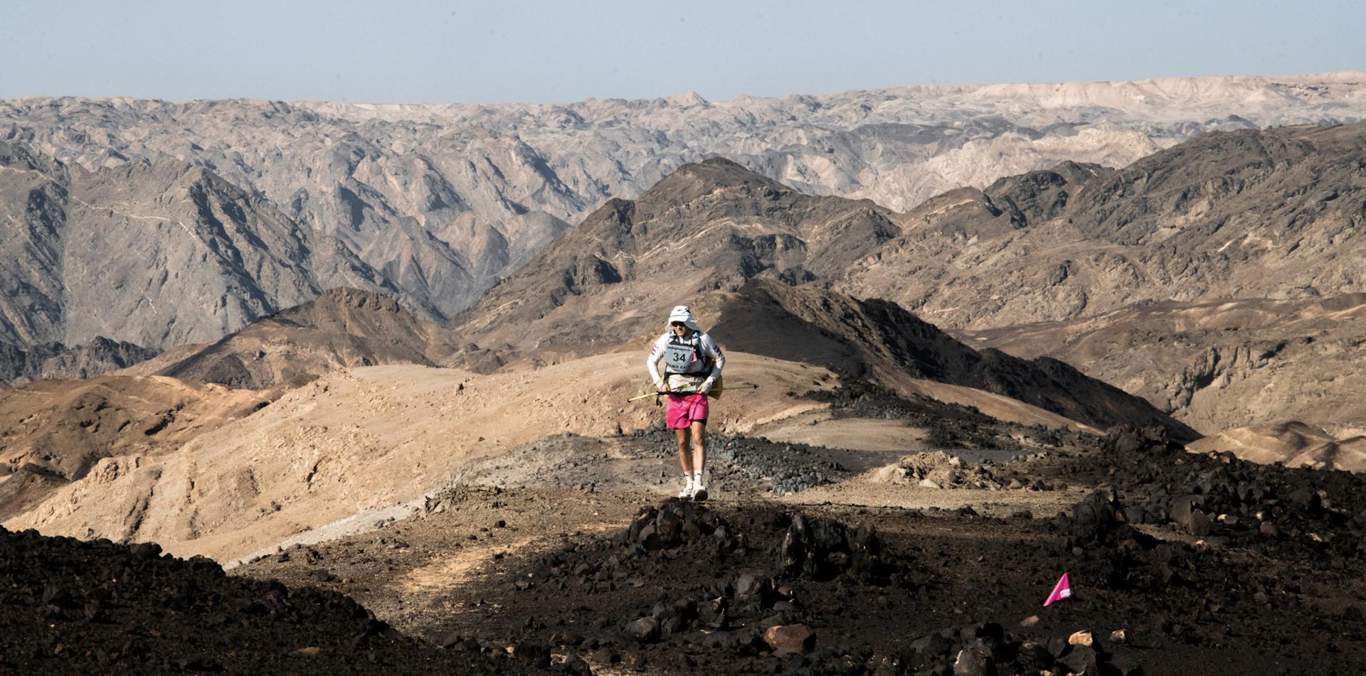
The Namib Race (Namibia) course does not have too much elevation gain or loss although you will at times be ascending and decending sand dunes and there is a big hill (Rossing Mountain) on Stage 5.
Much of the race takes place at or close to see level and the highest point is at 600 meters / 2,000 feet.
- Total Elevation Gain: 2,369 meters / 7,772 feet
- Total Elevation Loss: 2,374 meters / 7,788 feet
TERRAIN
There is a lot of sand on the course of the Namib Race. This is primarily in the areas on the beach and in the dunes. Much of the rest of the course is also sandy but with a layer of fine stones on top which is very nice terrain for running. There are also rocky sections and salt pans - the salt pans vary between very hard packed mud and corral-like terrain (without any water).
There are no planned river crossings, however depending on the level of the tide it is possible you could get your feet wet. It does also depend on what happens during the wet season - it is possible that some of the river beds have some water in them during the race.
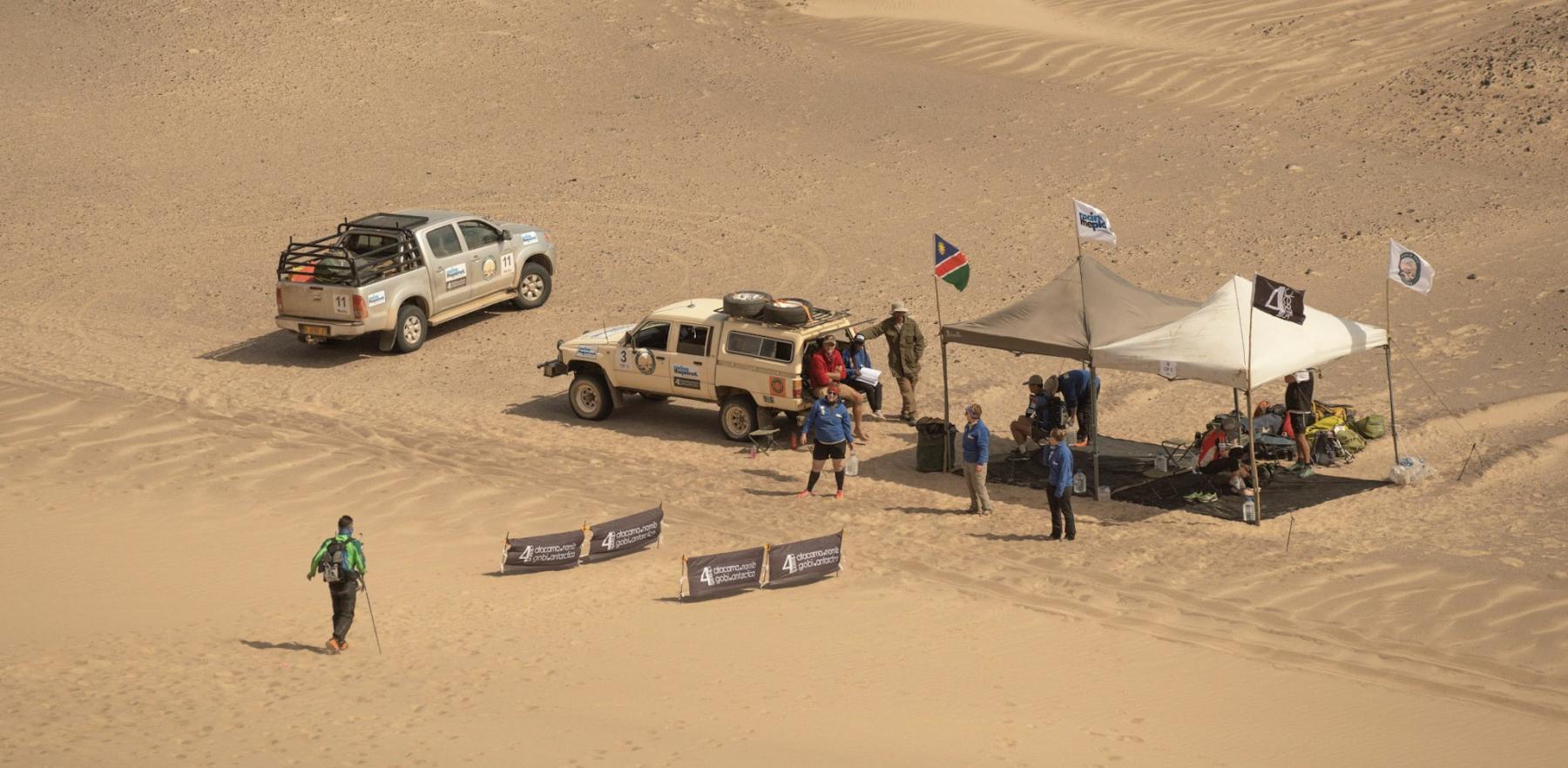
CHECKPOINTS
During each stage checkpoints are located approximately every 10 kilometers / 6 miles along the course. All checkpoints include shade, water for drinking (normally from a large bottle that you can fill your bottles from), volunteers to check you in and offer support and medical staff.
At each checkpoint competitors must:
- Be checked-in on arrival by the race staff.
- Leave with the minimum allocation of drinking water for the next section (in general this is 1.5 liters).
- Listen to and adhere to any instructions given by the race staff. This could be related to anything including advsere weather conditions (strong winds, thunderstorms, intense heat), visibility (sand storm, fog etc) or anything else.
At each checkpoint competitors can:
- Rest for a short time and take advantage of the shade the checkpoint tent offers.
- Seek medical advice and minor treatment if appropriate from the medical doctor stationed at each checkpoint.
- Ask details about the distance, terrain and elevation of the next section of the course.
Please note that adverse weather conditions, new obstacles or similar can result in changes being made to the course.
THE LONG MARCH
On one stage competitors complete a longer distance of approximately 80 kilometers / 50 miles which is nearly double the length of the standard stages. This stage is known as the Long March. The stage follows the same format as the previous stages, with checkpoints are located every 10kms / 6 miles, however there is a designated 'Overnight Checkpoint' where there will usually be tents to rest / sleep in and also hot water available to prepare a hot meal or hot drinks.
CUT-OFF TIMES
A cut-off time is the time by which you must have left a checkpoint. There are cut-off times for every checkpoint on the course - these are announced in the morning briefing before the start of each Stage. They are designed to help you finish, not to stop you.
While the leaders are extremely fast (finishing 40 kilometers / 26 miles in 3 - 4 hours) the cut-off times for the back of the field are designed based on a 4 km per hour / 2.5 miles per hour walking speed. This means completing a 40 kilometer / 26 mile stage in 10 hours.
Cut-off times for the Long March are based on a similar speed but with additional time allowed for a rest at the Overnight Checkpoint.